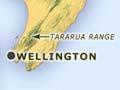

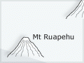
New Zealand’s alpine area totals about 30,000 square kilometres (about 11% of the country). Most is in the South Island, where several mountain peaks in the Southern Alps are higher than 3,000 metres. In the North Island, alpine terrain is limited to the volcanoes of the central plateau (Ruapehu, Ngāuruhoe and Tongariro), Mt Taranaki (Mt Egmont) to the west, Hikurangi to the east, and the crest of the axial ranges Kaweka, Kaimanawa, Ruahine and Tararua.
Alpine defined
The word ‘alpine’ is often used loosely to refer to anything to do with high mountains. Ecologists use the word to mean land above the upper altitudinal limit of trees. Strictly defined, it means the altitudinal zone between the timberline and the permanent snowline. Above that is ‘nival’.
Altitude zones
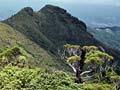
There are distinct bands of vegetation from the foot of a high mountain to its summit. Dark green forest gives way to tawny grassland, above which is apparently barren rock. Higher still, some of the rock is hidden beneath snow and ice.
Abrupt and gradual timberlines
The timberline or treeline (‘bushline’ to New Zealanders) – the highest elevation where trees can grow – is often a sharp ecological boundary. In New Zealand, timberlines formed by southern beech (Nothofagus) are typically abrupt – quite tall beech trees give way suddenly to tussock grassland.
Where beech is absent, such as on Mt Taranaki and in central Westland, the timberline can be gradual. Trees such as thin-bark tōtara (Podocarpus hallii) and rātā (Metrosideros umbellata) diminish in stature until they intermingle with subalpine scrub. Key members of subalpine scrub include shrub daisies such as leatherwood (Olearia colensoi) and Brachyglottis species, turpentine shrubs (Dracophyllum species), Hebe species and small-leaved, highly branched Coprosma species. Subalpine scrub and alpine grassland often intermix – tongues of grassland grow down into subalpine scrub, while spurs of low scrub and shrubland advance upwards.
Temperature threshold
It is not known why beech timberlines are so abrupt. New Zealand botanist Peter Wardle has argued that the critical factor is whether the growing season is long and warm enough for young shoots to finish growing and become sufficiently hardened to withstand the cold winter that follows. With increasing altitude, a tree’s ability to harden decreases. A common factor at timberlines throughout the world is that the mean temperature of the warmest month is about 10˚C.
The alpine belt
In the central region of New Zealand’s Southern Alps the alpine belt extends from 1,250 metres (timberline) to 2,000 metres (permanent snowline). In warmer, more northern parts of New Zealand, the lower limit of the alpine zone rises to 1,500 metres. On Stewart Island it descends to about 900 metres. At even more southerly latitudes in the subantarctic islands, the lower limit of the alpine zone is at sea level.
Low altitude alpines
Here and there, alpine plants grow at altitudes much lower than would be expected on the basis of temperature alone. For example, on Mt Moehau, at the northern tip of the Coromandel Peninsula, they occur at 892 metres. With a latitude of 36˚30’ south, the expected timberline would be at 1,750 metres. On Stewart Island, alpine vegetation descends almost to sea level in a few places, and is extensive on infertile, poorly drained, windswept uplands. On both Mt Moehau and Stewart Island, features of the soil (especially low fertility) and of climate other than temperature (especially wind) inhibit competition from taller-growing plants.