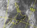
The fluctuations in New Zealand’s weather are caused by the passage of anticyclones (centres of high air pressure) separated by troughs of low pressure.
Fronts
Within the low-pressure troughs there are usually several bands of cloud and rain known as fronts. These form at the boundaries of air masses of different origin and temperature. Centres of low pressure, known as depressions, develop on some of the fronts.
Anticyclone weather
Anticyclones form when air currents in the high and middle atmosphere converge, piling up air in one area. The air inside these areas sinks from high levels towards the earth’s surface. The sinking air is warmed by compression, and this evaporates any cloud. This is why high pressure is generally – but not always – associated with good weather.
A cool story
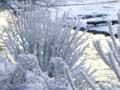
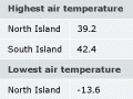
A spectacular frost occurred in Otago in early July 1991 when overnight air temperatures dropped below -15°C – for days in some places. The effect was chaos. Beer froze in pubs, water pipes burst, diesel turned to sludge, and rabbits with frostbitten ears were accused of cannibalism on national television. Exposed metal (such as gates) became so cold that skin froze to it on contact.
However, a layer of colder air is sometimes trapped below the sinking air, typically as cloud, and in winter this frequently produces drizzle. In summer, although the cloud usually evaporates before midday, its moisture often feeds the showers or thunderstorms that develop over certain locations – such as the Canterbury Plains.
Fine weather generally occurs in areas sheltered by a mountain range. The cloudiest areas are those where the wind blows from the sea onto the land, for instance Christchurch in a north-east wind.
Winds
Near the centre of an anticyclone the winds are typically very light. However, air in an anticyclone is generally stable and resists upward motion. Consequently, the air tends to dam up against large features, such as mountain ranges, and pour around the ends, sometimes causing gale force winds over the adjacent sea.
This effect contributes to typical wind patterns, including:
- frequent north-west gales over the sea south and west of Puysegur Point in Fiordland
- regular northerly and southerly gales in Cook Strait
- westerly and south-east gales near East Cape
- south-west gales off Kahurangi Point on the north-west of the South Island.
Frosts and fog
During long winter nights, frosts or fogs are likely to develop over land that the anticyclone leaves free of cloud. As the land becomes colder, it cools the air next to it. In the absence of any wind to mix the air, the surface air will rapidly cool below zero and frost will form. However, if the surface air contains enough water vapour, fog may result.
Lost in fog
During the Second World War, heavy fog over Auckland on the morning of 24 May 1942 served a double purpose: it hid ships in the harbour from a Japanese reconnaissance plane operating from a submarine waiting offshore, and New Zealand’s ground observers could not see the plane. Pilot Susumo Ito regained his bearings only after Auckland Airport’s lights were turned on – probably in response to the sounds of his plane circling.
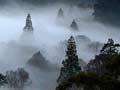
In high inland valleys, fog can form after the surface temperature falls below zero. This fog is composed of liquid droplets. When the fog droplets touch the surface of trees, fences or buildings they become rime ice, forming spectacular landscapes that can last for days. This can be seen in South Island inland areas. This phenomenon is called a hoar frost.
Pollution
In urban areas the light winds and stable conditions in anticyclones also favour the build-up of air pollution from car exhausts and industrial emissions. This occurs particularly in winter when open fires are being used.