Pahīatua
Main town of northern Wairarapa, set in the Mangatainoka River valley, with a 2013 population of 2,412. A wide garden strip dividing the town’s main street is a popular place for travellers to stop and picnic. The strip was set aside as a rail reserve, but in the end the railway bypassed the town.
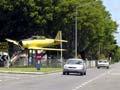
Pahīatua is a rural service centre for northern Wairarapa. Industries include milk products, confectionery and engineering. The town offers homestays and farmstays and has an enthusiastic railcar society. Its rivers are known for their brown trout.
History
Pahīatua was established in 1881 in the densely forested area known as the Forty Mile Bush. At first it was a timber town, but once the bush was cleared it became a service centre for the dairying and sheep farming hinterland. The town was made a borough in 1892. The town’s name comes from the Māori words for resting place (pahi) and god (atua). One interpretation is that a chief escaping from enemies was led by his god to a hill, where he rested.
People
In 2013, 20.9% of Pahīatua’s population was over 65 (compared to 14.3% nationally), a proportion partly explained by local farmers retiring to the town. A low proportion of people had post-school qualifications, probably reflecting limited work opportunities. Incomes were lower than the national average.
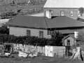
Pahīatua camp
The Pahīatua camp was set up during the Second World War to intern ‘enemy aliens’, who were moved there from Somes Island in 1943. In 1944 they were sent back to the island, and the camp became home to 734 Polish children, refugees from war-torn Europe. Most of them became New Zealanders. In 1975 some came back to Pahīatua to unveil a memorial sculpture on the site, just south of the town.
Helga’s story
Helga Tiscenko, who came to New Zealand from Germany after the Second World War, stayed in the Pahīatua camp. She arrived in Wellington and boarded a train to Wairarapa, noticing that the countryside was ‘unbelievably green’. She was also fascinated by the wooden houses, which were scattered across the landscape, rather than clustered as in a European village. At the camp, everything was ‘strange’ and Pahīatua ‘seemed so small’. Later, the strangeness went and she and her family became ‘fervent kiwis’. 1
Ballance
Farming settlement on the west bank of the Mangahao River, 11 km north-west of Pahīatua. Ballance is near the Tararua wind farm, the largest in the southern hemisphere. Named after Liberal politician (later premier) John Ballance, it was founded in 1886 as a government-sponsored settlement, but failed to thrive.
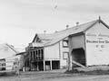
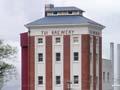
Mangatainoka
Township 5 km north of Pahīatua, on the banks of the Mangatainoka River, with a 2013 population of 1,560. It is best known for the Tui Brewery, set up in 1889. Its seven-storey tower is a local landmark. Associated with the brewery is the ABC bottling plant.
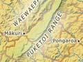
Pongaroa
Settlement 60 km south-east of Pahīatua. Pongaroa is a rural servicing centre. Settled in the 1890s, the town initially supported a timber mill. Once the bush was cleared, the land became sheep and beef cattle country. Pongaroa was the birthplace of Maurice Hugh Frederick Wilkins (1916–2004), who won a Nobel Prize in 1962 for his contribution to the discovery of the structure of DNA. It is also home to Papauma marae, established in 1904.