The history of Tāmaki (Auckland) shows the area to be a highly contested and rich resource, strategically located at the centre of several interconnecting trade routes running between Northland, Waikato, Coromandel and the Bay of Plenty. Tāmaki was visited by many of the important founding canoes, and several different iwi (tribes) have lived on the lands between its two harbours. Some tribes have occupied the area from the earliest times; others came and went, and some amalgamated to form new tribes.
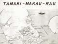
The name of Tāmaki
Because many tribes have lived in Tāmaki, there are numerous explanations for the origin of its name. One tradition says that Tāmaki refers to the narrow neck of land between the Waitematā and Manukau harbours, and that Tāmaki was an ancestor whose daughter married one of the original ancestors, Toitehuatahi. Another says that Tāmaki was the son of the Taranaki ancestor Maruiwi. Southern Taranaki tribes say that Tāmaki refers to a line of chiefs descended from their ancestress Parehuia. Some believe the name comes from the ancestor Maki or from one of his daughters. Yet another tradition claims that it comes from the 18th-century Te Wai-o-Hua chief Kiwi Tāmaki. A Waikato tradition traces the name to Tāmaki-makau-rau, a woman chief who was the daughter of Te Huia and the Ngāti Te Ata chief Te Rangikiamata.
Variations of the name include Tāmakinui (great Tāmaki), Tāmaki-makau-rau (Tāmaki of a hundred lovers), and Tāmaki-herehere-ngā-waka (Tāmaki that binds many canoes).
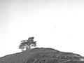
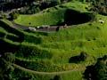
The mountains of the isthmus
Volcanic cones dominate the geography of Tāmaki, and oral traditions remember them in different ways. According to one tradition, the deity Mataaho lived in Te Ipu-a-Mataaho (the bowl of Mataaho – Mt Eden's crater). When his wife left him, taking all his clothes, Mataaho called on the goddess Mahuika. The fire she sent to warm him formed Ngā Huinga-a-Mataaho (the gathered volcanoes of Mataaho).
Another tradition explains that the volcanoes were formed when Hinemairangi – a patupaiarehe from the Hūnua Ranges in east Auckland – eloped with Tamaireia from the Waitākere Ranges in the west. A Hūnua war party sent to retrieve her was driven back when Waitākere priests chanted incantations, bringing down super-heated sunrays. The Hūnua priest responded in kind, and the isthmus erupted in fire. This event is celebrated in the name Te Pakūrangarāhihi (the battle of sunrays).
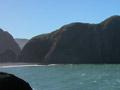
The waters of Hua
Māori tribes knew Tāmaki's two major harbours by different names. The northern harbour, according to Te Arawa tradition, was named Te Waitematā (the obsidian waters) by the ancestor Tamatekapua, after he placed a volcanic stone as a mauri (talisman) in its upper reaches near Birkenhead. Ngāpuhi call this harbour Te Wai-o-te-mate (the waters of death) because of the many struggles for control of the isthmus.
The southern harbour was named Mānuka (implanted post) in Te Arawa traditions, after the ancestor Īhenga, who put a stake there and claimed ownership of the waters. Tainui traditions name the harbour Te Mānukanuka-a-Hoturoa (the troublesome waters of Hoturoa) because of the sandbanks and quick-moving tides. More generally the harbour is known as the Manukau (wading birds), because birds such as the godwit and southern oystercatcher migrate there each summer.