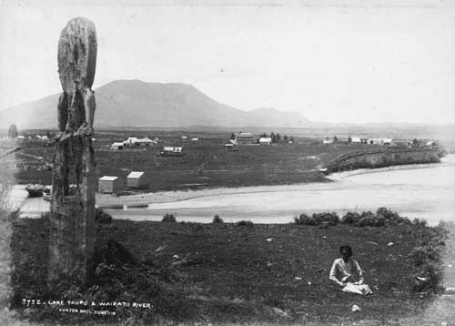
In the 1880s Tapuaeharuru, or Taupō, was little more than a scattering of houses on an open plain. The pou (post) in the foreground is adjacent to the Māori settlement of Nukuhau, across the Waikato River, which at this point begins its journey from Lake Taupō to the sea. In the middle distance is the Lake Hotel – a successor still occupies the same location on Tongariro Street. Tauhara mountain is in the distance.
Using this item
Alexander Turnbull Library, Burton Brothers Collection
Reference: PA1-o-088-11
by Burton Brothers
Permission of the Alexander Turnbull Library, National Library of New Zealand, Te Puna Mātauranga o Aotearoa, must be obtained before any re-use of this image.