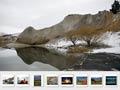


Dominated by inland ranges and basins, Otago also includes the southernmost peaks of the Southern Alps, coastal lowlands, and the Catlins hill country. It is more geographically diverse than the neighbouring regions of Canterbury and Southland, which are both centred on large plains. When the settlement of Dunedin was founded on Otago Harbour in 1848, it became a centre for both the interior and coastal regions. Otago’s landscapes have a wild and dramatic beauty that can sometimes also be bleak.
Māori
Large numbers of moa (large flightless birds) attracted Māori to the lower South Island, which they called Murihiku. However, by the time of European settlement moa were extinct and Māori were clustered on the coast. They identified themselves as Ngāi Tahu, and also with that tribe’s predecessors, Ngāti Māmoe and Waitaha. European sealers began arriving in the 1790s, and whalers in the 1800s; both intermarried with local Māori. They created a mixed-ancestry population which was later much outnumbered by European settlers.
Scots and gold
Otago is the product of its Scottish origins and its gold rushes. The solidity of the former and the wealth of the latter combined to create New Zealand’s most populous and wealthy city by the 1880s.
Development of Dunedin
In the late 19th century Dunedin spawned vigorous businesses and a strong labour movement. The city’s public spirit saw education, medicine, and causes such as missionary activity, temperance and women’s suffrage campaigns thrive. English, Irish Catholic, Jewish, Lebanese and Chinese immigrants added to the cultural mix.
In the 20th century Dunedin’s hinterland did not have the same scope for growth as North Island areas. The city ceded its primacy to northern cities. It remained regionally significant, and nationally prominent as a centre for higher education and medicine.
Regional and local government
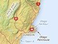
The region is commonly divided into North, South and Central Otago, and Dunedin. North Otago is centred on Ōamaru, South Otago on Balclutha, and Central Otago on Alexandra, Queenstown and Wānaka. West and East Otago designate smaller areas around Tapanui and Palmerston.
The local government districts are Queenstown Lakes, Central Otago, Clutha (South and West Otago), Waitaki (North and East Otago) and Dunedin City. The region is covered by Otago Regional Council, except for part of Waitaki district, which is affiliated with Canterbury Regional Council.
Plenty of space
With an area of 36,000 square kilometres, Otago is a bit larger than the Netherlands, Taiwan, or the US state of Maryland. But it has far fewer people – 202,000, compared with Maryland’s 6 million, 17 million Dutch and 24 million Taiwanese.
Population
Otago’s 2013 census population of just over 202,000 was 4.8% of the New Zealand total.
With 112,000 people in 2013, the Dunedin urban area accounted for 55% of the region’s population. The next largest urban centres were Queenstown and Ōamaru (both over 10,000), then Wānaka (6,481), Alexandra (4,800) and Balclutha (3,918).
The Queenstown Lakes district population almost doubled between 1996 and 2013, making it one of the fastest growing districts in New Zealand.
Over 14,000 Otago residents identified themselves as Māori in the 2013 census. Over two-thirds had ancestral links to Ngāi Tahu, the South Island’s main tribe.