Awatere River
The 113-km Awatere River rises on the Marlborough–Canterbury border. The high-country Acheron River probably at one point fed into the Awatere, but now flows south to join the Clarence; it is reached from the Awatere via Wards Pass.
In colonial times the Awatere was forded about 10 km upstream from the current bridge, at Taylors Ford, where there was an accommodation house from 1859 to 1904 and a settlement. In 2010 all that survives is a cemetery and the name Old Ford Road. Since the 1990s much of the alluvial plain has been turned over to grapes.
Black Birch
From 1984 to 1996 the US Naval Observatory operated a star-tracking station on Black Birch, a summit on the north bank of the Awatere River, until it was superseded by satellite navigation. In the 2010s Black Birch was the name of an Awatere valley winery.
Molesworth Station
New Zealand’s largest property takes in 185,000 hectares in the upper Awatere and Acheron river valleys and reaches into North Canterbury. The government took it over between 1938 and 1949. By controlling the rabbits, and replacing sheep with cattle, vegetation and productivity recovered. The road through Molesworth, following the Awatere then the Acheron River to Hanmer Springs, is open to tourists in summer.
Tapuae-o-Uenuku
New Zealand’s first recorded mountaineering death took place on Tapuae-o-Uenuku in 1849, when Wiremu Hoeta of Te Āti Awa, one of a party of nine attempting the climb, fell to his death. In 1864 the first successful ascent of the mountain was carried out by Nehemiah McRae, from the Welds Hill run in the Awatere valley, and two companions. The first solo climb was made by Blenheim schoolteacher W. J. Weiss in 1876. Annie and Florence Parsons of Kaikōura were the first women to make the ascent, in 1890. The highest trigonometrical station in New Zealand was erected on the summit in 1895. In the 1940s Edmund Hillary gained early climbing experience on the mountain.
Tapuae-o-Uenuku
The highest summit in New Zealand outside the Southern Alps (higher than any summit in the North Island), 2,885-m Tapuae-o-Uenuku (informally known as ‘Tappy’) is a part of the Inland Kaikōura Range, which divides the Awatere River from the Clarence valley.
Wither Hills
The outermost spur of the mountains that separate the Wairau, Waihopai and Awatere valleys. The first route across the hills was Taylor Pass. It was followed by a route closer to the coast through Redwood Pass, and in 1903 by a rail route through Dashwood Pass. The road through Dashwood and Weld passes was built in 1933.
On 26 December 2000 fire swept through the Wither Hills, destroying both pasture and recent reforestation. Walking tracks through the hills are easily reached from Blenheim.
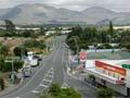
Seddon
Township on State Highway 1, 24 km south of Blenheim, on the south bank of the Awatere River, about 7 km from the coast. Seddon had a population of 504 in 2013.
In 1899 the government broke the 14,000-hectare Starborough estate into holdings averaging 1 square mile (260 ha) as part of the government’s closer settlement policy, and laid out a township named for the premier (like neighbouring Ward, named for his cabinet colleague).
In 2007 the vehicle bridge across the Awatere River, a single-lane structure underneath the railway line, was replaced by a standard road bridge. The vineyard demand for seasonal labour, recruited from the Pacific since 2006, has changed the township’s population make-up. In 2013, 6.3% of Seddon's population identified as Pacific, not far off the national figure of 7.4%, which is unusual for a township.
In 2011 the government was considering building a port in Clifford Bay, east of Seddon, for the roll-on, roll-off inter-island ferry from Wellington, but decided in 2013 to retain the Picton terminal.
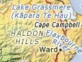
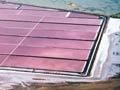
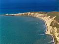
Lake Grassmere/Kāpara Te Hau
Former bay separated from Clifford Bay by sand dunes. Exposed to the north-west wind, the lake is known to Māori as Kāpara Te Hau (wind-ruffled waters). Ngāi Tahu defeated Te Rauparaha and his followers in a major battle at the lake in 1832–33. Salt was first produced there in 1952, and in the 2010s the lake met about 50% of New Zealand’s salt requirements.
Cape Campbell
The southern headland of both Clifford Bay and Cook Strait. Called Te Karaka by Māori, the cape was named by James Cook in 1770 for a British naval figure of the time. The 1903 lighthouse replaced an earlier one installed in 1870. A day return walk leads from Marfells Beach campground to the lighthouse.
Ward
Settlement on the Flaxbourne River, 50 km south of Blenheim on State Highway 1. Frederick Weld and Charles Clifford pastured the first sheep flock in the South Island there in 1847. The 23,000-hectare Flaxbourne estate was subdivided by the government in 1905 and the township was laid out and named after Joseph Ward, a cabinet minister. Disagreement between owners and government over the value of the land provoked two court cases before a figure was agreed on.
Waimā (Ure) River
One of the shorter Marlborough rivers, like the Flaxbourne and the Kēkerengū. In 2010 vineyards were a relatively new part of the Waimā valley landscape. The roadside church at Wharanui, 2 km south of the river, was built in 1924 by the Parsons family and consecrated by the Bishop of Nelson in that year.
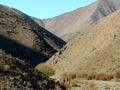
Sawcut Gorge (also known as Slot Canyon) is a dramatic limestone formation that can be reached by a 90-minute walking track 12 km up the Waimā River valley.