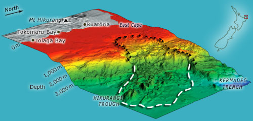
Looking like a landslide on any over-grazed hill, this submarine slide off East Cape is tens of thousands of times bigger. The slide occurred on a slope about the same height as Mt Cook. Blocks, some larger than Mt Ruapehu (18 kilometres wide), travelled nearly 50 kilometres out across a completely flat abyssal floor. Fortunately, it probably happened more than 155,000 years ago. It is thought that the slope may have been destabilised by a volcanic seamount on the Pacific Plate carried along towards and under the Australian Plate.
Using this item
Te Ara - The Encyclopedia of New Zealand
Source: NIWA – National Institute of Water and Atmospheric Research
This item has been provided for private study purposes (such as school projects, family and local history research) and any published reproduction (print or electronic) may infringe copyright law. It is the responsibility of the user of any material to obtain clearance from the copyright holder.