
Story: Ngāti Whātua

Ngāti Whātua tribal area

Image
Ngāti Whātua tribal area

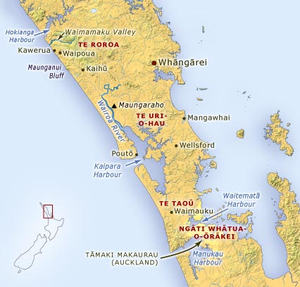
Ngāti Whātua-whānui or Ngāti Whātua-tūturu – ‘wider’ or ‘true’ Ngāti Whātua – refers to a confederation of four tribes: Te Roroa, Te Uri-o-Hau, Te Taoū, and Ngāti Whātua-o-Ōrākei. This map shows their lands, which span the area between the Hokianga Harbour and Tāmaki (Auckland).

Using this item

Te Ara - The Encyclopedia of New Zealand

This item has been provided for private study purposes (such as school projects, family and local history research) and any published reproduction (print or electronic) may infringe copyright law. It is the responsibility of the user of any material to obtain clearance from the copyright holder.

All images & media in this story

How to cite this page

Rāwiri Taonui, Ngāti Whātua – Origins, Te Ara – the Encyclopedia of New Zealand, https://teara.govt.nz/en/map/1195/ngati-whatua-tribal-area (accessed 21 June 2026).

Story by Rāwiri Taonui, published 4 March 2009, updated 1 March 2017.

Comments

Harriet
30 May 2018
Kia ora Raewyn, you are free to use these images for the purpose you describe. Thanks.
Raewyn Paewai
12 April 2018
Can you tell me who has the copyright for the following two images on your website, or how i could get digital copies. https://teara.govt.nz/en/map/2312/mahuhu-ki-te-rangi-landing-places https://teara.govt.nz/en/map/1195/ngati-whatua-tribal-area igital copies. I am researching on behalf of Ngati Whatua who are producing a History book for their Iwi. thanks Regards Raewyn
Terere Okapuni Wilson
08 February 2015
So enjoyed reading about my ancestors. My brothers Tapihana & Albert Shelford have shared many stories about our iwi Te Ori O Hau kaipara harbor. But it was good to re read again. Thank you.