The southern Kermadec Islands were first sighted from the convict ship Lady Penrhyn on 31 May 1788. Macauley Island is about 110 km south-west of Raoul Island, with Curtis Island another 35 km south. Captain Sever landed on the larger island, which he named (although with a different spelling) after Alderman George Mackenzie Macaulay of London. Curtis Island was named after Timothy and William Curtis, the ship’s owners.
The islands’ small size, difficult access and lack of water has deterred human settlement. The New Zealand government established castaway depots on Macauley and Curtis islands and L’Esperance Rock (80 km further south) soon after the Kermadecs were annexed.
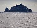
Macauley Island
Macauley Island is a tiny part of a large submerged volcanic complex which includes a 10-km-long caldera and an elongated dome dotted with tiny volcanic cones. The island covers only 3 square kilometres (including adjacent Haszard Island), and represents the gently sloping flank of a broad volcanic cone which has partly disappeared due to collapse and erosion.
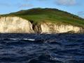
Cliffs at the north end of the island expose a spectacular section across the volcano, including white Sandy Bay ignimbrite, probably erupted from the nearby caldera several thousand years ago.
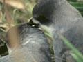
The island was originally covered with native forest, but fires and browsing by introduced goats changed the land to a rolling grassy meadow. Now that goats have been eradicated the vegetation is slowly returning, and bird numbers have greatly increased.
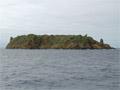
Curtis Island
French fields
The slaughter of sperm whales near the Kermadecs boomed in the early 19th century. At its height in the 1830s, up to 30 vessels could be seen in a single day near L’Esperance Rock, and the area became known as the French Rock whaling grounds.
A line of large pink barnacles 18 metres above sea level is an indication that the islands are rapidly rising. Bathymetric surveys indicate 7 metres of uplift between 1929 and 1964, and the bay where small boats previously landed is now above sea level.
Cheeseman Island is named after Thomas Cheeseman, the naturalist on the 1887 expedition to the Kermadecs, and Stella Passage between Curtis and Cheeseman islands is named for the expedition ship.