
Regional rainfall
In general, New Zealand gets plenty of precipitation in the form of rain, snow and ice. However, it is not evenly spread, and water is not always in the right places at the right time.
Rain, rain, rain
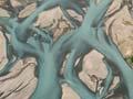
At 25°C air can hold three times as much water as air at 10°C. As the westerly airstream climbs to go over the Southern Alps, it cools and drops a lot of rain. One millimetre of rain falling over 1 square metre is 1 litre of water; on 1 hectare it is equivalent to 10,000 litres.
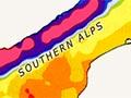
Regions to the east of the mountains in the South Island have a low annual rainfall, while those on the west have a very high rainfall. On a line from the west coast to the east coast through Queenstown, there are annual rainfalls ranging from 5,000 millimetres in the west to 350 millimetres in Central Otago. The variability is less in the North Island, but rainfall tends to be lower in the east, and higher in the centre and west of the island.
On the east coasts of both islands, annual rainfall ranges from 350 to 700 millimetres. Rainfall is generally about the same in winter as in summer, averaging 3–6 millimetres per day. However, in the hotter parts of the South Island evapotranspiration (loss of water from the soil due to evaporation and crop transpiration) ranges from about 1–2 millimetres per day in winter to 8–10 millimetres per day in summer. As a result, summer and autumn droughts are common, and irrigation is needed for crops and pasture to keep growing. Irrigation demand peaks in December and January.
Regional irrigation
Since the late 1970s the area of irrigated farmland has doubled every 12 years.
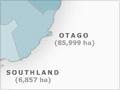
In 2006 irrigation consents had been granted for 972,653 hectares nationally. Of this, 88.9% was down the east coast of New Zealand, 66.5% in Canterbury, 14.5% in Otago, 4.1% in Hawke’s Bay and 3.8% in Marlborough. By 2007 about 80% of these consents had been actioned on an estimated area of 776,000 hectares.
Economic significance of irrigation
Irrigated land covers about 4% of New Zealand’s farmland. In dry land regions irrigated land produces three times as much animal or crop produce as an equivalent area that is not irrigated. The extra value is around $1 billion each year.
Drainage needs
In the west and centre of the North Island, the average annual rainfall ranges from 1,000 to 1,500 millimetres. With this high rainfall, the main tasks of early settlers and government were to protect settlements from flooding, improve agricultural land through drainage, and protect it from water erosion.
Some lowland soils receive runoff water from upland zones. Unless this is quickly drained, either overland or through the soil, the land becomes waterlogged. This slows the rate of vegetation growth and decomposition, and organic matter builds up on the surface. This is especially typical of land with peat soils such as the Hauraki Plains, or pakihi soil (from a Māori word that means open country) as on the West Coast.
Before human intervention, the soil of around 20% of New Zealand’s land area was wet, concentrated mainly in Northland, Waikato, Manawatū, Westland and the lowlands of Southland. Despite a low annual rainfall, the coastal areas of Canterbury and Hawke’s Bay also initially needed draining before they could be used for farming.