

Lower North Island and Marlborough, 2004
Between 14 and 17 February 2004, intense rain (up to 300 millimetres in two days) fell on land already saturated after previous severe weather. Worst affected were rivers in South Taranaki, Manawatū–Whanganui, Wellington and Marlborough. The Manawatū River peaked at its second-highest level on record. Many rivers breached their banks, spilling silt-laden flood water through towns and across farmland. A number of rural communities were evacuated. At the height of the emergency, about 2,300 people had to leave their homes and farms.
About half the roads in the Manawatū–Whanganui region were closed and more than 20 bridges were damaged. The civil defence operation was the largest in 20 years, with air force helicopters rescuing stranded people and dropping supplies to communities cut off by flood waters.
In Marlborough, the Waitohi River flooded parts of Picton, and 500 people were evacuated for fear an overflowing water supply dam might collapse.
The February floods cost over $112 million in insurance payouts, and the government granted $135 million in aid to farmers. Around 2,600 farmers were affected by the flooding, with some having to abandon their properties. The total economic impact was about $400 million.
Eastern Bay of Plenty, 2004
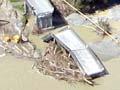
In July 2004, eastern Bay of Plenty was extensively flooded when a frontal system stalled over the area, causing prolonged and intense rain. The Whakatāne River spilled into the town’s central business district and the suburb of Awatapu. Water had to be released into the Rangitāiki River from the Matahina Dam to prevent the dam bursting. The Rangitāiki overflowed above Edgecumbe, creating a 100-metre-wide breach in its stopbanks. Flood waters entered Te Teko and Edgecumbe, and swamped some 17,000 hectares of farmland.
At the height of the floods, about 3,200 people had to leave their homes, many sheltering in evacuation centres and on local marae. A swarm of shallow earthquakes north-east of Rotorua added to the misery, triggering many landslides on saturated hillsides. More than 450 farms were affected by the floods, with over 200 homes made uninhabitable.
Cyclone Debbie and Cyclone Cook, 2017
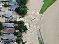
In April 2017, remnants of two tropical cyclones, Debbie and Cook, passed over New Zealand within a week of each other. Cyclone Debbie merged with a cold front to form a deep depression which dumped up to three times the normal April rainfall in three days on some areas. The Rangitāiki River again rose rapidly, and on 6 April a section of stopbank at Edgecumbe gave way. A torrent of water flooded into the town and inhabitants had just a few minutes to flee their homes. Many were marooned and had to be rescued by boats, tractors and trailers. About 2,000 people were evacuated from Edgecumbe.
In the South Island, Kaikōura was cut off when State Highway 1 south of the town was blocked by mudslides washed down from loose landslide debris from the November 2016 Kaikōura earthquake.
Rain from the remnants of Cyclone Cook caused flooding, slips and power outages along the east coast of the North Island. Hard-hit areas included Thames-Coromandel, Matamata, Tauranga, Whakatāne and parts of Hawke’s Bay.
Auckland Anniversary and Cyclone Gabrielle, 2023
On Friday 27 January 2023, the beginning of a long weekend marking the region’s anniversary, Auckland city was hit by an unprecedented deluge, with 249 millimetres of rain recorded at the airport in 24 hours (the previous record was 161.8 millimetres). Stormwater infrastructure was soon overwhelmed and low-lying areas were flooded. Hundreds of landslides fell from cliffs of relatively soft sandstone and mudstone rock.
Three people died in Auckland and one at Onewhero in Waikato. Several hundred people were injured. Hundreds of houses were rendered uninhabitable and thousands of cars had to be written off because of water damage. Nearly 100 roads were closed because of flooding or slips. There was also flooding in Northland, Waikato and Bay of Plenty. Both State Highway 1 to Whangārei and the North Auckland railway line were impassable for months. Power outages and loss of cellphone coverage was widespread.
Just a fortnight after the Anniversary weekend storm, a much wider area – the entire east coast of the North Island, from Northland to Wairarapa – was struck by the remnants of Cyclone Gabrielle. As with Cyclone Bola, Gabrielle’s movement was slowed by a blocking anticyclone, prolonging the heavy rain. In some areas, 300 to 400 millimetres fell in 48 to 60 hours. Esk Valley, just north of Napier, received 500 millimetres in 24 hours, half of this in six hours in the middle of the night.
Eleven people died (eight of them in Hawke’s Bay) and dozens were rescued from rooftops by helicopters and the brave skippers of small boats. Once again, hundreds of people were injured, hundreds of homes became uninhabitable, and there were widespread power outages and loss of cellphone coverage. An estimated 10,000 people were forced to leave their homes, at least temporarily.
The total cost of these events was expected to exceed $10 billion, with half to two-thirds of this covered by insurance. By way of comparison, the Canterbury earthquakes of 2010/11 are thought to have cost the economy around $40 billion.