
Story: Māori Land Court – Te Kōti Whenua

Department of Lands and Survey, 1896

Image
Department of Lands and Survey, 1896

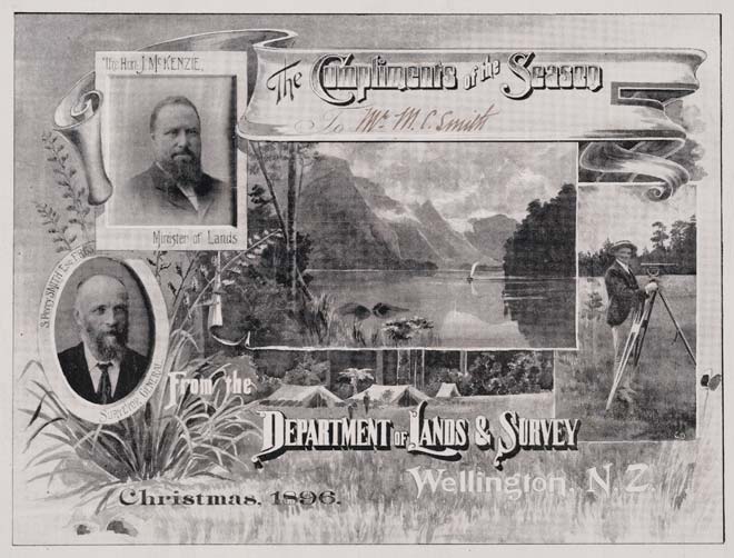
This handsome Lands and Survey Department Christmas card from 1896 shows some of the key figures in the process of surveying Māori land for sale through the Native Land Court. At left are John McKenzie, minister of lands (top), and S. Percy Smith, surveyor-general. At right is a surveyor with his theodolite (a precision instrument used in surveying). The main background image shows a surveyors' camp in the New Zealand bush.

Using this item

Alexander Turnbull Library

Reference: A-174-001

Permission of the Alexander Turnbull Library, National Library of New Zealand, Te Puna Mātauranga o Aotearoa, must be obtained before any re-use of this image.

All images & media in this story

How to cite this page

Mere Whaanga, Māori Land Court – Te Kōti Whenua – Surveying and other costs, 1880–1900, Te Ara – the Encyclopedia of New Zealand, https://teara.govt.nz/en/ephemera/36141/department-of-lands-and-survey-1896 (accessed 4 June 2026).

Story by Mere Whaanga, published 12 June 2012.

Comments

Maureen Panui
16 March 2018
How do I get information on the survey plans of the block we are living on? We live on the Makarau 2B1 block which had to be resurveyed because one of the houses was halfway on our section. Our family trust is NGA URI O HARE PANUI WHANAU TRUST and we are trying to find those papers so we can see whether we have used up our fathers shares or do which is 81.200 or if we need to survey more and pay our own rates. Thank you so much for taking the time to help.