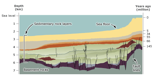
This cross-section of the rock layers in the Taranaki Basin, north-west of the Taranaki coastline, shows sedimentary rock layers, which can be up to 7 kilometres thick. The vertical lines are faults that have offset the rock layers. Faults may act as upward routes for oil and gas trying to rise to the surface. Faults also offset underlying rock layers, creating gaps between permeable and impermeable rocks, where oil and gas can be trapped. Sedimentary basins such as this are the most likely places in New Zealand to find oil and gas in the future.
Using this item
New Zealand Petroleum & Minerals, Ministry for Economic Development
This item has been provided for private study purposes (such as school projects, family and local history research) and any published reproduction (print or electronic) may infringe copyright law. It is the responsibility of the user of any material to obtain clearance from the copyright holder.