Image
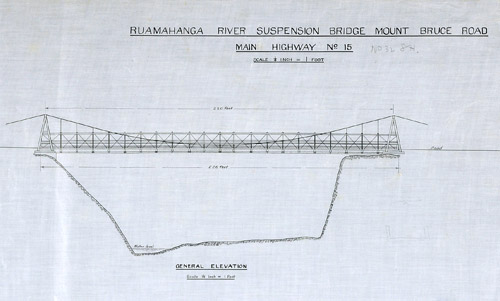
These drawings for a suspension bridge across the Ruamāhanga River near Mt Bruce were prepared by the Public Works Department in 1926. The department, established in 1870, had initially project-managed the building of major bridges and tunnels. In the first half of the 20th century it also became involved in designing and building bridges.
Using this item
Archives New Zealand - Te Rua Mahara o te Kāwanatanga
Reference: AAOB 6006 W3138 2 WDO 15022 RUAMAHANGA BRIDGE PLAN 1926
Permission of Archives New Zealand Te Rua Mahara o te Kāwanatanga must be obtained before any re-use of this material.