
Story: Whangārei tribes

‘Entrance to Whangari river, bearing NW by W’

Image
‘Entrance to Whangari river, bearing NW by W’

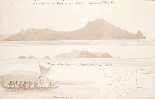
Whangārei Harbour is at the heart of the Whangārei tribes’ territory. This journal illustration is by Edward Ashworth, an architect who lived in Auckland from 1842 to 1844. At the top, it depicts Manaia, near the northern entrance to the harbour, and below that, the offshore Hen and Chickens Islands (Taranga and Marotiri). In the bottom left corner is a Māori canoe, which might have been seen on the harbour in the 1840s, and at bottom right there is a map of Bream Head, the northern entrance to the harbour.

Using this item

Alexander Turnbull Library

Reference: MS-0104-071

by Edward Ashworth

Permission of the Alexander Turnbull Library, National Library of New Zealand, Te Puna Mātauranga o Aotearoa, must be obtained before any re-use of this image.

All images & media in this story

How to cite this page

Rāwiri Taonui, Whangārei tribes – Ancestors, Te Ara – the Encyclopedia of New Zealand, https://teara.govt.nz/en/artwork/4074/entrance-to-whangari-river-bearing-nw-by-w (accessed 4 June 2026).

Story by Rāwiri Taonui, published 4 March 2009, updated 1 March 2017.

Comments


16 November 2015
Kia ora, Lorna. Thanks for this - you are welcome to use Te Ara text for your paper. (All our text is licensed under the Creative Commons Attribution-NonCommercial 3.0 New Zealand Licence unless otherwise stated). Regards, Jamie Mackay
Loma Cleave
16 November 2015
morning , what an interesting paper. I am currently at Te Wanaga O Aoteroa in Mangere and am researching into my history, Ngatiwai and was hoping i could use some of your information in this article? I look forward to your reply.