
Story: Ngāti Porou

Mt Hikurangi

Image
Mt Hikurangi

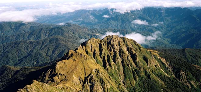
Hikurangi is the sacred mountain of Ngāti Porou, and was said to be the first piece of land to emerge when Māui fished up the North Island. According to tradition, Māui’s canoe, Nukutaimemeha, remains stranded on the mountain peak. Hikurangi was acquired by the Crown in the 1870s and became a state forest park. In November 1990 the Crown signed a deed with Te Rūnanga o Ngāti Porou, vesting in them 3,780 hectares which included Hikurangi. Ngāti Porou now manage the land and facilitate public access to the mountain.

Using this item

GNS Science

Reference: 41063

by Lloyd Homer

Permission of GNS Science must be obtained before any use of this image.

All images & media in this story

How to cite this page

Tamati Muturangi Reedy, Ngāti Porou – Tribal boundaries and resources, Te Ara – the Encyclopedia of New Zealand, https://teara.govt.nz/en/photograph/4282/mt-hikurangi (accessed 4 June 2026).

Story by Tamati Muturangi Reedy, published 4 March 2009, updated 1 March 2017.

Comments

Malta koia
15 April 2017
The Ngatiporpou runganga does not have the mandate to settle land claims on behalf of Ruawaipu,Uepohatu and Te Hautiti a Aitanga they do not own the land . In 2012 the government put through a act in parliament stopping the waitangi tribunal from looking further into the claims of Ruawaipu descendants.The identity of Ruawaipu was lost after the 1865 East Coast wars when all the marae's and pa's were burnt down.When Rawiri Katea Koiauriterangi signed te tiriti of Waitangi the maori version not the (treaty of waitangi there are two versions) he did not concede soverntity over Ruawaipu lands foreshore or seabed.