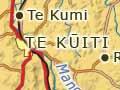

Te Kūiti
Rural service town 20 kilometres south-west of Ōtorohanga and 80 kilometres north-west of Taumarunui, with a 2013 population of 4,221. Te Kūiti is on the intersection of state highways 3 and 30. The main trunk railway line runs through the middle of the town, which is the seat of the Waitomo District Council.
Meadsville
During the 2011 Rugby World Cup, which was held in New Zealand, Te Kūiti was re-named ‘Meadsville’ to honour the contribution of local rugby legend Colin Meads and his brother Stan to the town and the sport. A Tui beer billboard sported the new name, as did a sign at the entrance to the town, the railway station and shops in the town centre.
A Māori village called Te Kūititanga stood at the entrance to the Mangaōkewa Gorge at the south end of present-day Te Kūiti. The second Māori king, Tāwhiao, lived there in exile after Waikato tribal lands were confiscated by the government following the land wars of the 1860s.
In 1887 the main trunk railway line reached Te Kūiti, where a camp was set up to house construction workers. This formed the nucleus of a busy new township. Te Kūiti was the end of the line until 1894, when the tracks reached the Poro-ō-tarao tunnel to the south-east. The workers departed and Te Kūiti became much quieter.
The town’s fortunes revived after farms were established to the south and west from the late 1890s. The population grew from 1,266 in 1911 to 1,982 in 1916. Te Kūiti became a self-governing borough in 1910.
However, growth was not underpinned by strong economic foundations – farming production was still small, soil fertility was declining and some farmers left to fight overseas during the First World War. The government bought town sections to on-sell to settlers just before the local economy slumped in the 1920s and had trouble selling them. The population still grew but at a much slower rate.
Growth picked up again after the Second World War. The population increased from 2,720 in 1945 to a peak of 4,842 in 1971. It declined from the 1980s.
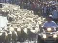
Te Kūiti has branded itself as the sheep-shearing capital of New Zealand. During the town’s annual Great New Zealand Muster, between 1,000 and 2,000 sheep run down the main street.
Unusual origins
During the 1930s economic depression a camp for unemployed men was set up at Pururu, near Rangitoto. The men lived in tents and slept in bunk beds. Recreational opportunities were few and far between and the residents had little to do when they were not working. They went on strike in protest. This tactic was successful and a recreation hall was built. After the camp was closed the building became the Rangitoto district hall.
Rangitoto
Rural settlement 10 kilometres east of Te Kūiti on the western slopes of the Rangitoto Range. The first European settlers arrived in 1904. Rangitoto School opened in 1920, closed for a time, and re-opened in 1923.
Waitomo Caves
Rural settlement and tourist village, 19 kilometres north-west of Te Kūiti. The area is riddled with caves, some of which are accessible to the public. The Glow-worm, Aranui and Ruakurī caves are owned by Māori and the Department of Conservation, and leased to Tourism Holdings, which runs cave tours. Other less well-known caves, such as Hollow Hole and Gardener’s Gut, are explored unguided by caving enthusiasts.
Intrepid travellers
Early visitors to the Waitomo Caves had to be made of stern stuff. A woman who visited the Glow-worm Cave in 1902 wrote: ‘Most of the caves were damp from the constant drip of the water from overhead; the flooring of some of the upper caves was covered with a greasy white substance similar to modelling clay … We had to climb down some wooden step ladders that were unpleasantly slippery … one felt very insecure holding the rail in one hand and the candle in the other, trying to grope along in the darkness that was only made visible by the flickering candles.’1
A tourist village is located near the Glow-worm Cave. The Waitomo Caves Discovery Centre (formerly the Waitomo Museum of Caves) opened in 1972. Waitomo Caves School has served the district since 1910.
Ōparure
Rural settlement 8 kilometres north-west of Te Kūiti and 10 kilometres south of Waitomo Caves. The area is full of limestone caves.
Ōparure Native School opened in 1902 after Ruita Te Mihinga Joseph, a local landowner, donated land for this purpose. The school is now Te Wharekura o Ōparure, a Māori-language immersion school.
Mairoa
Rural settlement 28 kilometres south-west of Te Kūiti, first settled by Europeans in 1903. Dairy farms were established throughout the district.
The town that wasn’t
In 1911 a town site was surveyed at Waitanguru, near Mairoa. The survey plan laid out town sections and streets and made provision for public buildings, a cemetery, creamery, saleyards and mechanics’ institute. The sections were sold but the town did not eventuate. A number of the sections were on steep land and some were full of limestone rock formations. A history of the district published in 1975 noted that some people held onto their sections for decades in the hope a town would develop.
Mairoa epitomised the difficulties faced by farmers working on volcanic soils of low fertility and lacking in cobalt – the wasting disease suffered by animals grazed on these lands, sometimes called ‘bush sickness’, was dubbed ‘Mairoa dopiness’. These problems were compounded by economic depression. By 1940, 55 of the 106 settlers who took up farms around Mairoa, Ngapāenga, Mangaōtaki and Waitanguru had walked off the land.
After the Second World War the Department of Lands and Survey rehabilitated abandoned farms, which were farmed by returned servicemen. Cobalt-enriched fertiliser solved fertility problems and bush sickness. Aided by aerial fertiliser topdressing, farms were converted from dairy to beef and sheep.