Image
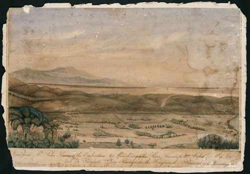
Wilbraham Liardet painted this view of the ‘River Thames’ (Waihou River) in 1869, with the kāinga (village) of Parawai in the foreground. The view looks south to Te Aroha mountain. Parawai is the southern part of the present-day town of Thames. Since 1867 the area immediately north of the kāinga had been overrun by miners, after the discovery of gold in the Kauaeranga River; to the south, there is no evidence of that activity.
Using this item
Reference: C-137-005
by Wilbraham Frederick Evelyn Liardet
Permission of the Alexander Turnbull Library, National Library of New Zealand, Te Puna Mātauranga o Aotearoa, must be obtained before any re-use of this image.