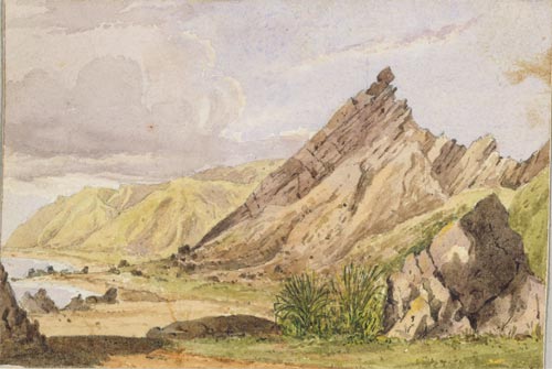
Ngā Rā o Kupe (Kupe’s Sails), depicted in this 1850s watercolour by William Mein Smith, is on the eastern shore of Palliser Bay. The name was originally given to two triangular patches of light-coloured cliff that stood out from the green vegetation of the surrounding hills. The story behind the name is that Kupe and his companion Ngake camped there and argued over who could make a sail the quickest. Kupe completed his sail before Ngake and won. After the contest they hung the sails up against the cliffs.
Using this item
Reference: E-011-f-004
by William Mein Smith
Permission of the Alexander Turnbull Library, National Library of New Zealand, Te Puna Mātauranga o Aotearoa, must be obtained before any re-use of this image.