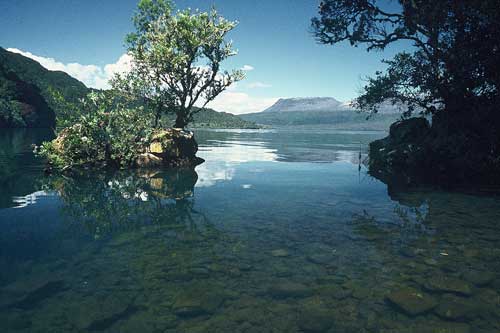
Mt Tarawera can be seen in the distance across Lake Tarawera. The volcano has erupted several times in the last 15,000 years, but its distinctive stumpy shape today was formed by the eruption of steep-sided lava domes about 800 years ago. On 10 June 1886 Tarawera erupted again, apparently with little warning. A 17-kilometre rift was blasted through the mountain and Lake Rotomahana, and the surrounding area was devastated. Over 100 people were killed, and many were left homeless. The rift cannot be seen from this angle, and the shape of the mountain was unchanged.
Te whakamahi i tēnei tūemi
Reference: 10050460
by Chris Rudge
This item has been provided for private study purposes (such as school projects, family and local history research) and any published reproduction (print or electronic) may infringe copyright law. It is the responsibility of the user of any material to obtain clearance from the copyright holder.