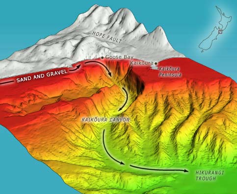
Sand swept north along the continental shelf is trapped by the Kaikōura Canyon. Every few hundred years earthquakes cause underwater landslides, and the trapped sand falls down the canyon. As the landslide moves down the slope and mixes with water, it forms a sediment-laden flow known as a turbidity current. Because they are heavier than the water, the currents hug the bottom of the canyon, flowing down to the flat floor of Hikurangi Trough at depths of 2,000 metres or more, and continuing along the Hikurangi Channel.
Using this item
Te Ara - The Encyclopedia of New Zealand
Source: NIWA – National Institute of Water and Atmospheric Research
This item has been provided for private study purposes (such as school projects, family and local history research) and any published reproduction (print or electronic) may infringe copyright law. It is the responsibility of the user of any material to obtain clearance from the copyright holder.