Image
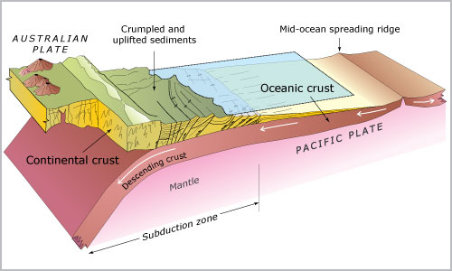
This east–west cross-section through the central part of the North Island illustrates how the Pacific Plate descends (subducts) beneath the Australian Plate acts rather like a bulldozer's blade, and the sediments on top of the Pacific Plate are scraped off and crumpled, forming the hills of the Wairarapa and Hawke's Bay.
Te whakamahi i tēnei tūemi
Source: Ray Wood and others, New Zealand’s continental shelf and UNCLOS Article 76. Lower Hutt: Institute of Geological and Nuclear Sciences; Wellington: National Institute of Water and Atmospheric Research, 2003
Permission of GNS Science must be obtained before any use of this image.