


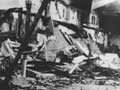
The Modified Mercalli scale (from 1 to 12) measures earthquakes by the intensity of shaking observed. Reports from historical records and diaries have been used to compile this map, which shows the shaking from the Hawke’s Bay earthquake of 3 February 1931. A total of 256 people were killed, mainly in the urban centres of Napier and Hastings, and the earthquake was widely felt over much of the North Island.
Te whakamahi i tēnei tūemi
Te Ara – The Encyclopedia of New Zealand
This item has been provided for private study purposes (such as school projects, family and local history research) and any published reproduction (print or electronic) may infringe copyright law. It is the responsibility of the user of any material to obtain clearance from the copyright holder.
Source: G. L. Downes, Atlas of isoseismal maps of New Zealand earthquakes. Lower Hutt: Institute of Geological and Nuclear Sciences, 1995.
Tāpiritia te tākupu hou