


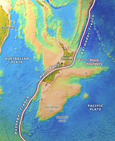
This map shows the plate boundary that runs through New Zealand. Off the North Island’s east coast, and north of it, oceanic crust of the Pacific Plate dives (subducts) beneath the continental crust of the Australian Plate, forming the Hikurangi Trough. At the other end of the country, off the south-west corner of the South Island, the situation is reversed. Oceanic crust of the Australian Plate subducts beneath the continental crust of the Pacific Plate.
Te whakamahi i tēnei tūemi
Te Ara - The Encyclopedia of New Zealand
This item has been provided for private study purposes (such as school projects, family and local history research) and any published reproduction (print or electronic) may infringe copyright law. It is the responsibility of the user of any material to obtain clearance from the copyright holder.
Source: Ray Wood and others, New Zealand’s continental shelf and UNCLOS Article 76. Lower Hutt: Institute of Geological and Nuclear Sciences; Wellington: National Institute of Water and Atmospheric Research, 2003
Tukunga
for my knowledge
Rudy Nayoan (not verified)
04 o Tīhema 2013
Tāpiritia te tākupu hou