


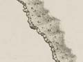
This map of New Zealand shows the coastline as Cook charted it during his first visit in 1769–70. It was published in Sydney Parkinson’s Journal of a voyage to the South Seas (1773). The track of the Endeavour around New Zealand is also shown. Of particular interest is Cook’s depiction of Banks Peninsula as an island and Stewart Island as a possible peninsula. Overall, however, this chart provided an extremely accurate outline of New Zealand for future visitors.
Using this item
Alexander Turnbull Library
Reference:
PUBL-0037-25
Permission of the Alexander Turnbull Library, National Library of New Zealand, Te Puna Mātauranga o Aotearoa, must be obtained before any re-use of this image.
Comments
I agree, would love to print
Loreen Brehaut (not verified)
16 September 2015
Would it be possible to put
Mark Hansen (not verified)
21 January 2012
Add new comment