


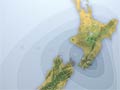
On this map, isoseismal lines show the Mercalli effects (the intensity of shaking) for the earthquake of 2 August 1942. Like the earthquake of 24 June, the shaking was felt over most of New Zealand, with highest intensity in the Wairarapa.
Using this item
Te Ara – The Encyclopedia of New Zealand
This item has been provided for private study purposes (such as school projects, family and local history research) and any published reproduction (print or electronic) may infringe copyright law. It is the responsibility of the user of any material to obtain clearance from the copyright holder.
Source: G. L. Downes, Atlas of isoseismal maps of New Zealand earthquakes. Lower Hutt: Institute of Geological and Nuclear Sciences, 1995.

Comments
I am doing a project on this
Taylah (not verified)
18 March 2011
Add new comment