


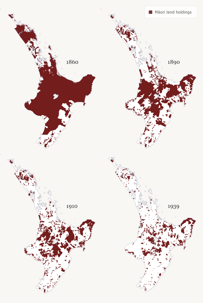
These maps illustrate the gradual alienation of Māori land in the North Island. In 1860, Māori still held onto most of their land, except for a few areas, particularly Wellington, Wairarapa, Hawke’s Bay and parts of Northland. The 1860s saw confiscations of huge areas by the government and large areas of land began to be lost through the effect of the Native Land Court. The period between 1890 and 1920 saw a boom in government land purchases, despite Māori protests. By 1937, very little land was left in Māori ownership.
Using this item
Te Ara - The Encyclopedia of New Zealand
This item has been provided for private study purposes (such as school projects, family and local history research) and any published reproduction (print or electronic) may infringe copyright law. It is the responsibility of the user of any material to obtain clearance from the copyright holder.
Source: Claudia Orange, Illustrated history of the Treaty of Waitangi. Wellington: Bridget Williams Books, 2001, pp. 318–319


Comments
The Native Land Acts were
Huia Hohepa (not verified)
27 July 2023
I would like to know where
Elizabeth Mokaraka (not verified)
12 October 2022
It would be interesting to
marie (not verified)
21 June 2012
no way
charmaine (not verified)
14 January 2011
Add new comment