


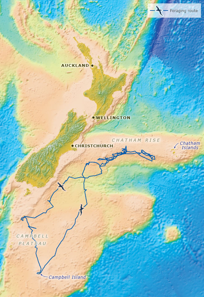
Some albatrosses travel great distances from their nests in search of food. The arrows mark the journey taken by a female southern royal albatross, from her nest on Campbell Island to the Chatham Rise and back. As shown, she mostly fed along steep underwater cliffs, where New Zealand's continental shelf drops away. Her movements were tracked by a tiny satellite transmitter fitted to her body. She flew for almost 16 days, while her mate took his turn sitting on the egg. She covered the first 900 kilometres in 24 hours – an average of 37.5 kilometres per hour. Her furthest point from the colony was 1,200 kilometres, but she flew a total of 6,000. A saltwater sensor showed that just over half of her time was spent in flight; she sat on the water for the remainder.
Using this item
Te Ara – The Encyclopedia of New Zealand
This item has been provided for private study purposes (such as school projects, family and local history research) and any published reproduction (print or electronic) may infringe copyright law. It is the responsibility of the user of any material to obtain clearance from the copyright holder.
Base map: GNS Science. Data: C. Troup, ‘Foraging strategies of southern royal albatrosses.’ M.Appl.Sc thesis, Lincoln University, 2004

Comments
My wife and I visited the
Alan Robson (not verified)
01 January 2023
Add new comment